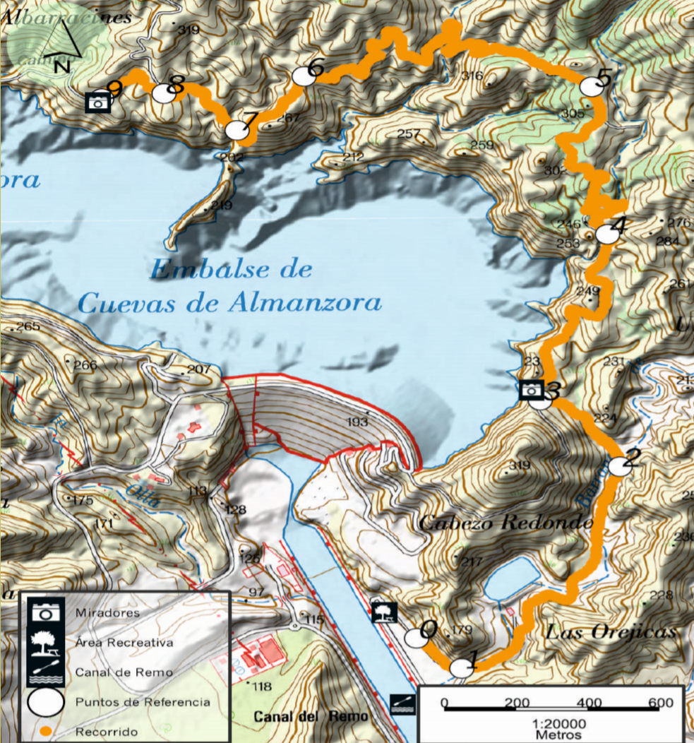
• Weather

    This area enjoys a mediterranean and arid weather. During the year, there is a quite low frequency of precipitation, which results in mild winters with no frosts and warm summers.

    Image
  • Relevant Vegetation and Fauna

    The natural areas are normally bushy, herbaceous and nonforest, playing an important role in soil preservation, regulation of soil infiltration, overflow and local climate.
    - Arborescent scrublands of Ziziphus
    - Halophilic steppes (Limonietalia) and Gypsophila

    Image
  • Fauna

    One particular specie of Alto de Almagro SAC (Special Area of Conservation) is the Greek Tortoise Clestudo graeca graeca) commonly known as the spur-thighed tortoise, and several bird species such as the fojden eagle (Aquila chrysaetos) and the urasian eagle-owl (Bubo bubo}. Regarding mammals, you can easily spot wild boars, goats and wildcats, rabbits, moles and ormouses.

    Image
  • How to get there

    In order to get to the starting point of the trail, first you should take the road A-322 and get to the urban core of Cuevas de Almanzora. Once there, look for the local sign “El Alhanchete’, which will take you to the reservoir alongside the right bank of river Almanzora.
    The Recreation Area of Canoeing and Rowing Venue can be spotted on the left bank of the river, which is the reason why it is best to cross the river over one of the two elevated walkways and follow the dirt path that goes up alongside the river until you reach the Recreation Area.

  • The starting point of this route is at the Recreation Area of the Canoeing and Rowing Venue, after which you will pass the Orejicas del Diablo and then you will turn left through Rambla Avellan. It raises passing by a pond where, to the left, it joins a ravine that will take you to a reforestation track after you have walked uphill for about 10 minutes.
    The trail runs up through a more gentle slope which will come across another ravine that will take you to a fork in the trail where both directions are just as good. If you choose left, the path will soon turn into alane as you walk down until you cross a small ravine.

    The route follows the contour around the reservoir through little slope areas leading to a mountain pass where the path seems to go down straight to the reservoir. However, as you continue the trail, you will spot to your right a small dam. After you cross the ravine, the path rises again to find Camino de Los Albarracines, a concrete path that goes down a slight slope towards the viewpoint Mirador del Pantano as the destination of the trail.
    If you wish to go back to the Recreation Area of the Canoeing and Rowing Venue, you should follow the route in the opposite direction.

    Image
Article Picture
Description.

ROUTE TYPE: Linear
STARTING POINT: Recreation Area of the Canoeing and Rowing Venue
DESTINATION: End of the concrete path Camino de Los Albarracines
DISTANCE: Main route 5.7 km
TIME SPENT: 1 hour and 55 minutes (one way)
MAXIMUM HEIGHT: 298 m MINIMUM HEIGHT: 91 m
UNEVENNESS: Climb: 319 m / Descent: 166 m
PATH TYPE: Pavements and horseshoe paths (61%) and dirt (34%) and concrete roads (5%)
MAPPING: Sheets MTN25 996-1V and 1014-11.


Download route